Table of Contents
- Introduction
- About the Seismic Risk Assessment in Japan
- Top 5 Most Vulnerable Areas to Earthquakes in Tokyo
- Conclusion (Implications)
1. Introduction: The Shock of the First Tatami Room
I still vividly remember the time when I first moved to Japan and lived in a tatami room of an old wooden house. One night, I experienced an earthquake for the very first time in my life. Looking back now, it was a relatively minor tremor of seismic intensity 3 or 4, but the experience of the ‘solid ground beneath my feet’ literally shaking side-to-side was a massive, unprecedented culture shock. It went far beyond a simple natural disaster; it instilled in me an entirely new worldview—one where a haunting ‘fear lies dormant within everyday life.’
As everyone knows, Japan is a highly earthquake-prone country. Because of this existential dread of earthquakes that seeps into one’s bones, thorough preparation for seismic risks is an absolute necessity, not just for short-term living, but critically from a mid-to-long-term real estate investment perspective. It goes without saying that a careful approach is crucial to protecting precious lives and property. Among the many regions in Japan, today we will specifically examine these highly vulnerable areas that could prove fatal in a worst-case scenario, focusing on the capital, Tokyo.
2. About the Seismic Risk Assessment in Japan
As an earthquake-prone country, Japan regularly investigates and announces regional risk levels related to earthquakes. This post introduces the findings based on the “Regional Risk Measurement Survey Regarding Earthquakes (7th Edition)” published in 2013. This survey measures hazards based on building structures such as wooden and reinforced concrete buildings, the age of the buildings, the number of floors, the total number of structures, the use of hazardous materials based on building purpose, and the current maintenance status of roads and parks.
A key feature of this survey is that it does not assume a specific earthquake will happen, operating on the premise that it is unknown when or where an earthquake might occur. Needles to say, no matter how much technology advances, predicting the exact occurrence of an earthquake remains extremely difficult. Instead, the “Regional Risk Measurement Survey Regarding Earthquakes” assigns identical earthquake conditions to every region to measure relative hazard levels. In other words, by examining the details of the survey, one can understand the characteristics of the ground and buildings in a given area.
The risk level ranking follows a relative evaluation method that measures how high a region ranks compared to all other regions. Therefore, even if a region’s absolute safety improves, its ranking might still drop if other regions become comparatively safer.
3. Top 5 Most Vulnerable Areas to Earthquakes in Tokyo
Evaluated based on the risk of building collapse and the risk of fire among the 23 wards of Tokyo, the top 5 most hazardous areas are listed in the table below.
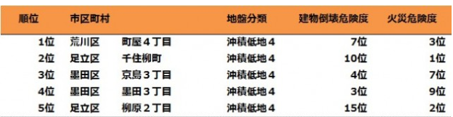
1st place is Machiya 4-chome in Arakawa Ward, 2nd is Senjuyanagi-cho in Adachi Ward, 3rd is Kyojima 3-chome in Sumida Ward, 4th is Sumida 3-chome in Sumida Ward, and finally, 5th place goes to Yanagihara 2-chome in Adachi Ward. For reference, “chome” is a geographic division similar to specific numbered streets or blocks in other countries. You can safely understand it as a single block unit.
Arakawa Ward, Adachi Ward, and Sumida Ward occupy the top spots. All of these areas are located in alluvial lowlands. Because alluvial lowlands are primarily composed of sediments deposited below sea level, there is a high probability that they will amplify the shaking in the event of an earthquake.
The 1st place, “Machiya 4-chome, Arakawa Ward,” ranked 7th in building collapse risk and 3rd in fire risk. Since it ranked high in both overarching risk categories, it seized 1st place in overall total risk. The 2nd place, “Senjuyanagi-cho, Adachi Ward,” ranked 1st in fire risk level. This is believed to be primarily due to a very high density of buildings. The 3rd place, “Kyojima 3-chome, Sumida Ward,” ranked 4th in building collapse risk and 7th in fire risk, indicating highly dangerous levels in both aspects.
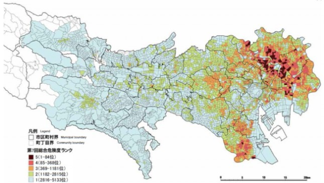
These areas correspond to the locations marked in red on the right side of the map below. Excluding the central core of Tokyo, it can be seen that the surrounding eastern areas are relatively more vulnerable to earthquake damage. While short-term residency might be less concerning, referencing such maps is considered absolutely essential for anyone contemplating mid-to-long-term real estate investments.
4. Conclusion (Implications)
It has been revealed that areas with high risk ratings in Tokyo are primarily concentrated in bustling downtown districts along the Arakawa and Sumida rivers. Of course, these results are simply indicators meant to present hazard levels clearly and are not intended to model a specific impending earthquake. Nevertheless, regarding earthquake hazards represented by building collapses and fires, there is a clear necessity to be informed in advance and to make optimal efforts in preparation.
For example, if you already know an area has a high fire risk, selecting a property within that region that has relatively lower building density could serve as a means to mitigate that risk. Regarding the risk of building collapse, one must comprehensively consider factors such as the age of the building and whether it meets strict earthquake-resistant architectural standards. Approaching investments armed with this minimum checklist will help safeguard your valuable assets.